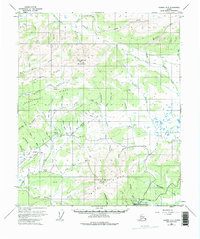
1953 Map of Tanana A-2
USGS Topo · Published 1975About this map
Manley Hot Springs lies at the southern edge of this interior landscape, positioned at the base of Bean Ridge. The 1950s terrain is defined by a dense network of gold-bearing watercourses and mining infrastructure, particularly evident in the series of ditches that contour around Serpentine Ridge and Boulder Ridge. These hydraulic features, along with the numerous namesake gulches like Innesvale Gulch and Dalton Gulch, illustrate a landscape heavily modified by early 20th-century placer mining efforts.
Find a feature on this map
61 named features on this map. Tap any name to fly to it.
Don’t see what you’re looking for? This feature index may not catch every label — zoom into the map to look around manually.
Map Details
Editions of this 1953 Tanana A-2 Map
3 editions found
Other maps of this area

1948 · Kantishna River
USGS Topo · 1:250,000

1951 · Kantishna River
USGS Topo · 1:250,000

1951 · Tanana
USGS Topo · 1:250,000

1952 · Tanana A-1
USGS Topo · 1:63,360

1952 · Tanana A-3
USGS Topo · 1:63,360

1952 · Tanana A-2
USGS Topo · 1:63,360

1952 · Kantishna River
USGS Topo · 1:250,000

1952 · Kantishna River D-2
USGS Topo · 1:63,360

1952 · Kantishna River D-3
USGS Topo · 1:63,360

1953 · Tanana A-2
USGS Topo · 1:63,360