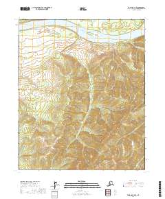
2017 Map of Tanana B-1 NW
USGS Topo · Published 2017About this map
The Yukon River dominates the northern landscape of this interior Alaskan region, carving a wide channel that defines the local geography. Near the center of the waterway, Sixmile Island sits as a prominent landform within the river's path, indicating the shifting sediment patterns of this massive drainage system. The surrounding terrain is heavily dissected by numerous tributaries, including Sixmile Cr, Marshall Cr, and Russian Cr, which flow from the interior uplands toward the river valley. In the southeastern corner, Ruby Cr adds to the complex network of drainage that characterizes the Yukon-Koyukuk Census Area. This 2017 survey illustrates a wilderness shaped almost entirely by its water systems, where the lack of established settlements emphasizes the role of the river as the primary corridor for movement and natural resource distribution.
Find a feature on this map
12 named features on this map. Tap any name to fly to it.
Don’t see what you’re looking for? This feature index may not catch every label — zoom into the map to look around manually.
Map Details
Editions of this 2017 Tanana B-1 NW Map
This is the sole edition of this map. No revisions or reprints were ever made.
Other maps of this area

1951 · Tanana
USGS Topo · 1:250,000

1956 · Tanana B-1
USGS Topo · 1:63,360

1956 · Tanana C-1
USGS Topo · 1:63,360

1956 · Tanana B-2
USGS Topo · 1:63,360

1956 · Tanana C-2
USGS Topo · 1:63,360

1956 · Tanana
USGS Topo · 1:250,000

1960 · Tanana
USGS Topo · 1:250,000
2017 · Tanana C-1 SW
USGS Topo · 1:25,000
2017 · Tanana B-2 SE
USGS Topo · 1:25,000
2017 · Tanana C-2 SE
USGS Topo · 1:25,000