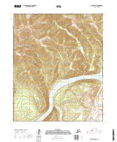
2017 Map of Tanana B-2 NW
USGS Topo · Published 2017About this map
The Yukon River cuts a deep course through this interior Alaskan wilderness, channeled specifically through the dramatic Rampart Gorge. This corridor serves as a primary geographic artery, where the river is flanked by the rising elevations of Raven Ridge. The landscape is defined by the high-relief drainage patterns of numerous tributaries, including Canyon Cr to the north and Stevens Cr and Fisher Cr to the south. The map illustrates a region largely untouched by road infrastructure, where the natural water systems and topographic ridges provide the only navigable landmarks. Further east, Garnet Cr feeds into the main river channel, highlighting the complex hydrography that has shaped this portion of the Yukon-Koyukuk region.
Find a feature on this map
13 named features on this map. Tap any name to fly to it.
Don’t see what you’re looking for? This feature index may not catch every label — zoom into the map to look around manually.
Map Details
Editions of this 2017 Tanana B-2 NW Map
This is the sole edition of this map. No revisions or reprints were ever made.
Other maps of this area

1951 · Tanana
USGS Topo · 1:250,000

1956 · Tanana B-2
USGS Topo · 1:63,360

1956 · Tanana C-3
USGS Topo · 1:63,360

1956 · Tanana B-3
USGS Topo · 1:63,360

1956 · Tanana C-2
USGS Topo · 1:63,360

1956 · Tanana
USGS Topo · 1:250,000

1960 · Tanana
USGS Topo · 1:250,000
2016 · Tanana B-3 NE
USGS Topo · 1:25,000
2016 · Tanana C-3 SE
USGS Topo · 1:25,000
2016 · Tanana B-3 SE
USGS Topo · 1:25,000