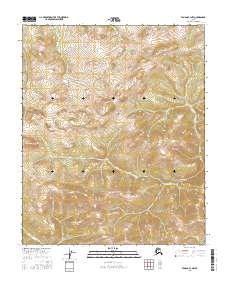
2016 Map of Tanana B-3 NW
USGS Topo · Published 2016About this map
Rampart Mountains dominate the central topography of this Interior Alaska quadrangle, situated in a remote stretch of the Yukon-Koyukuk region. This 2016 survey documents the complex drainage systems that carve through the high ground, notably the headwaters of Bear Cr and Forks Cr in the northern and eastern sections. In the southwest, the terrain slopes toward the basin of Morelock Cr, while Rosa Cr defines the drainage pattern in the southeast. The map is a precise record of the Public Land Survey System grid, illustrating the boundaries of Townships 6 through 8 North and Ranges 18 through 19 West. There are no roads or settlements shown, highlighting the wilderness character of the terrain between the Yukon and Tanana rivers.
Find a feature on this map
11 named features on this map. Tap any name to fly to it.
Don’t see what you’re looking for? This feature index may not catch every label — zoom into the map to look around manually.
Map Details
Editions of this 2016 Tanana B-3 NW Map
This is the sole edition of this map. No revisions or reprints were ever made.
Other maps of this area

1951 · Tanana
USGS Topo · 1:250,000

1956 · Tanana C-3
USGS Topo · 1:63,360

1956 · Tanana B-3
USGS Topo · 1:63,360

1956 · Tanana C-4
USGS Topo · 1:63,360

1956 · Tanana B-4
USGS Topo · 1:63,360

1956 · Tanana
USGS Topo · 1:250,000

1960 · Tanana
USGS Topo · 1:250,000
2016 · Tanana B-3 NE
USGS Topo · 1:25,000
2016 · Tanana B-4 SE
USGS Topo · 1:25,000
2016 · Tanana C-3 SW
USGS Topo · 1:25,000