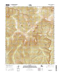
2016 Map of Tanana B-5 SE
USGS Topo · Published 2016About this map
Hellbent Cr flows through the northern reaches of this interior Alaskan landscape, which remains largely defined by its drainage systems and elevation changes. In this remote portion of the Yukon-Koyukuk region, the hydrology is the primary indicator of the terrain's character. The eastern portion of the sheet is marked by the winding course of Bear Cr, while Tenmile Cr cuts through the southwestern quadrant. These named waterways represent the only named landmarks in an otherwise wilderness area, categorized by the U.S. Geological Survey within the public land survey system across townships T6N and T5N. The map provides a precise record of the natural topography before any significant human development or road networks reached these specific coordinates.
Find a feature on this map
7 named features on this map. Tap any name to fly to it.
Don’t see what you’re looking for? This feature index may not catch every label — zoom into the map to look around manually.
Map Details
Editions of this 2016 Tanana B-5 SE Map
This is the sole edition of this map. No revisions or reprints were ever made.
Other maps of this area

1951 · Tanana
USGS Topo · 1:250,000

1952 · Tanana A-4
USGS Topo · 1:63,360

1952 · Tanana A-5
USGS Topo · 1:63,360

1953 · Tanana A-5
USGS Topo · 1:63,360

1956 · Tanana B-5
USGS Topo · 1:63,360

1956 · Tanana B-4
USGS Topo · 1:63,360

1956 · Tanana
USGS Topo · 1:250,000

1960 · Tanana
USGS Topo · 1:250,000
2016 · Tanana B-5 SW
USGS Topo · 1:25,000
2016 · Tanana B-5 NE
USGS Topo · 1:25,000