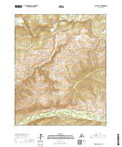
2017 Map of Tanana D-1 NW
USGS Topo · Published 2017About this map
Ray River and Big Salt River define the primary drainage patterns of this subarctic wilderness in the Tanana D-1 NW quadrangle. The terrain is characterized by a series of high, unnamed ridges separated by these major waterways, which flow through the northern and southern portions of the sheet respectively. This 2017 survey provides an exacting record of the topographic contours and hydrographic features before any modern development or road infrastructure reached this section of the interior. The landscape is segmented into townships and ranges such as t14n r14w and t13n r13w, marking the formal Public Land Survey System divisions that overlay this largely untouched natural environment.
Find a feature on this map
8 named features on this map. Tap any name to fly to it.
Don’t see what you’re looking for? This feature index may not catch every label — zoom into the map to look around manually.
Map Details
Editions of this 2017 Tanana D-1 NW Map
This is the sole edition of this map. No revisions or reprints were ever made.
Other maps of this area

1951 · Bettles
USGS Topo · 1:250,000

1951 · Tanana
USGS Topo · 1:250,000

1956 · Bettles
USGS Topo · 1:250,000

1956 · Tanana D-2
USGS Topo · 1:63,360

1956 · Tanana D-1
USGS Topo · 1:63,360

1956 · Tanana
USGS Topo · 1:250,000

1960 · Tanana
USGS Topo · 1:250,000
1970 · Bettles A-1
USGS Topo · 1:63,360
1970 · Bettles A-2
USGS Topo · 1:63,360
2017 · Tanana D-1 NE
USGS Topo · 1:25,000