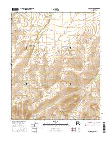
2016 Map of Tanana D-3 SW
USGS Topo · Published 2016About this map
The Kanuti Kilolitna River meanders across this interior landscape within the Tanana D-3 SW quadrangle, following a course shaped by the high ridges of the Ray Mountains. The terrain is defined by dramatic elevation changes, with the northern reaches of the sheet dominated by the winding path of Torment Cr. This 2016 survey illustrates the hydrography of the Alaskan interior before modern development, focusing on the natural drainage patterns that define the region's geography. The survey provides clear documentation of the township and range lines, including t11n r18w and t12n r18w, which serve as the primary markers for this uninhabited stretch of the Yukon-Koyukuk region. Researchers can trace the complex network of mountain streams and steep contour lines that characterize this part of the Alaskan wilderness.
Find a feature on this map
6 named features on this map. Tap any name to fly to it.
Don’t see what you’re looking for? This feature index may not catch every label — zoom into the map to look around manually.
Map Details
Editions of this 2016 Tanana D-3 SW Map
This is the sole edition of this map. No revisions or reprints were ever made.
Other maps of this area

1951 · Tanana
USGS Topo · 1:250,000

1956 · Tanana D-4
USGS Topo · 1:63,360

1956 · Tanana D-3
USGS Topo · 1:63,360

1956 · Tanana C-3
USGS Topo · 1:63,360

1956 · Tanana C-4
USGS Topo · 1:63,360

1956 · Tanana
USGS Topo · 1:250,000

1960 · Tanana
USGS Topo · 1:250,000
2016 · Tanana D-4 SE
USGS Topo · 1:25,000
2016 · Tanana D-4 NE
USGS Topo · 1:25,000
2016 · Tanana D-3 SE
USGS Topo · 1:25,000