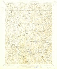
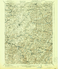
1911 Map of Taneytown
USGS Topo · Published 1925About this map
Taneytown and the surrounding borderlands of Carroll County serve as a focal point for this 1908–1909 survey, illustrating the dense agricultural and industrial development between Maryland and Pennsylvania. The landscape is defined by the high ground of Parrs Ridge and the winding courses of Big Pipe Creek and Little Pipe Creek. This era was marked by a robust local economy driven by milling and rail transit, with numerous family-operated sites like Arters Mill, Markers Mill, and Wolfs Mill appearing along the waterways. The transit network is prominently displayed, featuring the Northern Central RR and Western Maryland RR, which connected agricultural hubs like Union Bridge and New Windsor to broader markets.
Find a feature on this map
112 named features on this map. Tap any name to fly to it.
Don’t see what you’re looking for? This feature index may not catch every label — zoom into the map to look around manually.
Map Details
Editions of this 1911 Taneytown Map
6 editions found

Other maps of this area

1892 · Ellicott
USGS Topo · 1:62,500

1893 · Frederick
USGS Topo · 1:125,000

1894 · Ellicott
USGS Topo · 1:62,500

1894 · Frederick
USGS Topo · 1:125,000

1905 · Westminster
USGS Topo · 1:62,500

1906 · Ellicott
USGS Topo · 1:62,500

1908 · Patapsco
USGS Topo · 1:125,000

1908 · Gettysburg
USGS Topo · 1:62,500

1908 · Ijamsville
USGS Topo · 1:62,500

1909 · Mount Airy
USGS Topo · 1:62,500