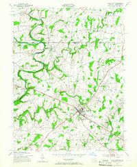
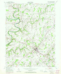
1953 Map of Taneytown
USGS Topo · Published 1966About this map
Taneytown sits at a crossroads of mid-century commerce and agriculture, serving as the hub for a landscape defined by the winding Monocacy River and Piney Creek. This area, updated just after the war, reflects a transition from rural solitude to suburban-style amenities, evidenced by the Drive-in Theater near Bridgeport and the County Fairgrounds on the town's edge. The map preserves the locations of local pillars like the Taneytown School and the Hoffman Orphanage, alongside industry such as Mairs Mill on Marsh Creek. Small agrarian clusters like Harney, Longville, and Stumptown are scattered across the valley, while the presence of the Mt Joy Church and several cemeteries including Sunrise Cemetery and Piney Creek Cemetery provide a detailed view of the community's established social geography near the Pennsylvania state line.
Find a feature on this map
37 named features on this map. Tap any name to fly to it.
Don’t see what you’re looking for? This feature index may not catch every label — zoom into the map to look around manually.
Map Details
Editions of this 1953 Taneytown Map
5 editions found
Other maps of this area

1908 · Gettysburg
USGS Topo · 1:62,500

1909 · Fairfield
USGS Topo · 1:62,500

1911 · Taneytown
USGS Topo · 1:62,500

1911 · Emmitsburg
USGS Topo · 1:62,500

1942 · Gettysburg
USGS Topo · 1:125,000

1943 · Emmitsburg
USGS Topo · 1:62,500

1944 · Union Bridge
USGS Topo · 1:31,680

1944 · Gettysburg
USGS Topo · 1:31,680

1944 · New Windsor
USGS Topo · 1:31,680

1944 · Mc Sherrystown
USGS Topo · 1:31,680