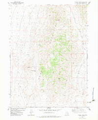
1983 Map of Tangent Peak
USGS Topo · Published 1983About this map
The Hogup Mountains dominate this high-desert landscape in northern Utah, as documented in this 1983 edition. The terrain is defined by prominent summits such as Tangent Peak and Scorpio Peak, with several prospects scattered across the slopes, indicating history of mineral exploration in this arid range. These mining-related features are often found near the complex ridgelines and drainages that funnel into Big Wash.
Find a feature on this map
10 named features on this map. Tap any name to fly to it.
Don’t see what you’re looking for? This feature index may not catch every label — zoom into the map to look around manually.
Map Details
Editions of this 1983 Tangent Peak Map
This is the sole edition of this map. No revisions or reprints were ever made.
Other maps of this area

1954 · Brigham City
USGS Topo · 1:250,000

1958 · Brigham City
USGS Topo · 1:250,000

1962 · Brigham City
USGS Topo · 1:250,000

1969 · Dolphin Island West
USGS Topo · 1:24,000

1969 · Hogup Ridge North
USGS Topo · 1:24,000

1969 · Hogup Bar
USGS Topo · 1:24,000
1969 · Crocodile Mtn SE
USGS Topo · 1:24,000

1971 · Matlin
USGS Topo · 1:24,000

1983 · Sheep Mountain
USGS Topo · 1:24,000

1983 · Groome
USGS Topo · 1:24,000