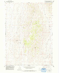
1991 Map of Tangent Peak
USGS Topo · Published 1992About this map
The Hogup Mountains of Box Elder County dominate this 1991 topographic record, a landscape defined by desert peaks and dry washes. Rising above the Great Salt Lake Desert, the terrain is anchored by Tangent Peak and Scorpio Peak, with high-elevation routes like Big Pass and Shelter Mountain Pass providing the only navigable paths through the range. The map reveals the area's history of mineral exploration through several identified prospects scattered along the mountain flanks, while a lone Storage Bin and various 4wd tracks indicate the limited human infrastructure present in the late twentieth century. This survey, revised from earlier aerial photography, captures the stark geography of the Shelter Mountain vicinity before modern changes, documenting a remote corner of Utah where natural landmarks like Big Wash are the primary points of orientation.
Find a feature on this map
10 named features on this map. Tap any name to fly to it.
Don’t see what you’re looking for? This feature index may not catch every label — zoom into the map to look around manually.
Map Details
Editions of this 1991 Tangent Peak Map
This is the sole edition of this map. No revisions or reprints were ever made.
Other maps of this area

1954 · Brigham City
USGS Topo · 1:250,000

1958 · Brigham City
USGS Topo · 1:250,000

1962 · Brigham City
USGS Topo · 1:250,000

1969 · Dolphin Island West
USGS Topo · 1:24,000

1969 · Hogup Ridge North
USGS Topo · 1:24,000

1969 · Hogup Bar
USGS Topo · 1:24,000
1969 · Crocodile Mtn SE
USGS Topo · 1:24,000

1971 · Matlin
USGS Topo · 1:24,000

1983 · Sheep Mountain
USGS Topo · 1:24,000

1983 · Groome
USGS Topo · 1:24,000