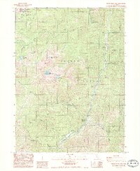
1986 Map of Tangle Blue Lake
USGS Topo · Published 1986About this map
Scott Mts form a formidable backdrop for this high-elevation mountain terrain within the Klamath National Forest and Shasta National Forest. The landscape is defined by the headwaters of the Trinity River and a network of glacial lakes including Tangle Blue Lake, Big Bear Lake, and Log Lake. Evidence of human activity in this wilderness area is scattered between the Pacific Crest National Scenic Trail and various 4WD tracks. Small clearings like Sunflower Flat and Sunny Flat offer breaks in the dense forest, while locations such as Messner Cabin and Trumble Ranch indicate isolated residential or operational outposts. The presence of the Grand National Mine suggests historical mineral exploration near Tangle Blue Creek, while established sites like Eagle Creek Campground and Horse Flat Campground provide modern utility for backcountry travelers and surveyors.
Find a feature on this map
42 named features on this map. Tap any name to fly to it.
Don’t see what you’re looking for? This feature index may not catch every label — zoom into the map to look around manually.
Map Details
Editions of this 1986 Tangle Blue Lake Map
2 editions found
Other maps of this area

1886 · Shasta
USGS Topo · 1:250,000

1894 · Shasta
USGS Topo · 1:250,000

1923 · Sawyers Bar
USGS Topo · 1:125,000

1931 · Etna
USGS Topo · 1:96,000

1934 · Etna
USGS Topo · 1:125,000

1948 · Weed
USGS Topo · 1:250,000

1950 · Weed
USGS Topo · 1:250,000
1955 · Bonanza King
USGS Topo · 1:62,500
1955 · China Mountain
USGS Topo · 1:62,500

1955 · Etna
USGS Topo · 1:62,500