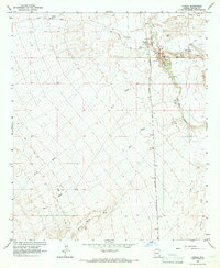
1966 Map of Tanque
USGS Topo · Published 1967About this map
The settlement of Tanque and the nearby L L Ranch define the human footprint in this arid landscape as it was recorded in the mid-1960s. The region is shaped by the drainage patterns of the San Simon River, which is fed by numerous desert watercourses such as Owl Wash and Cove Draw. Transportation and communication are anchored by the Southern Pacific railroad line, which runs north-to-south parallel to the river. This alignment illustrates the historical reliance on natural corridors for rail infrastructure in the desert Southwest.
Find a feature on this map
24 named features on this map. Tap any name to fly to it.
Don’t see what you’re looking for? This feature index may not catch every label — zoom into the map to look around manually.
Map Details
Editions of this 1966 Tanque Map
2 editions found
Other maps of this area

1917 · San Simon
USGS Topo · 1:125,000

1922 · Willcox
USGS Topo · 1:125,000

1928 · Bowie
USGS Topo · 1:62,500

1944 · Fisher Hills
USGS Topo · 1:62,500

1949 · Bowie
USGS Topo · 1:62,500

1950 · Bowie
USGS Topo · 1:62,500

1954 · Silver City
USGS Topo · 1:250,000

1957 · Luzena
USGS Topo · 1:62,500

1958 · Silver City
USGS Topo · 1:250,000

1962 · Silver City
USGS Topo · 1:250,000