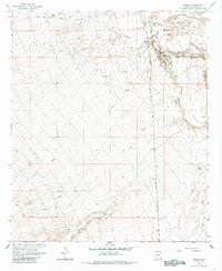
1966 Map of Tanque
USGS Topo · Published 1985About this map
The Southern Pacific railroad corridor defines this mid-1960s landscape in Graham County, running parallel to the San Simon River through a region of high-desert drainage patterns. The small settlement of Tanque sits at a critical junction of rail and road, supported by a Gaging Station and various water sources essential for livestock and steam-era infrastructure. The terrain is deeply incised by seasonal waterways including Willow Spring Wash, Owl Wash, and Cove Draw, which underscore the precarious nature of water management in this arid environment.
Find a feature on this map
14 named features on this map. Tap any name to fly to it.
Don’t see what you’re looking for? This feature index may not catch every label — zoom into the map to look around manually.
Map Details
Editions of this 1966 Tanque Map
2 editions found
Other maps of this area

1917 · San Simon
USGS Topo · 1:125,000

1922 · Willcox
USGS Topo · 1:125,000

1928 · Bowie
USGS Topo · 1:62,500

1944 · Fisher Hills
USGS Topo · 1:62,500

1949 · Bowie
USGS Topo · 1:62,500

1950 · Bowie
USGS Topo · 1:62,500

1954 · Silver City
USGS Topo · 1:250,000

1957 · Luzena
USGS Topo · 1:62,500

1958 · Silver City
USGS Topo · 1:250,000

1962 · Silver City
USGS Topo · 1:250,000