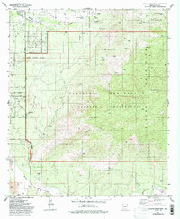
1981 Map of Tanque Verde Peak
USGS Topo · Published 1993About this map
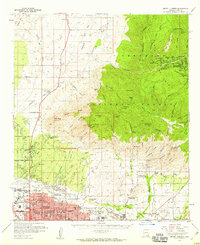
Tanque Verde Peak and the high ridges of the Rincon Mountains dominate this 1980s landscape on the eastern edge of Tucson. The map illustrates a transitional zone where residential expansion along Speedway Road and Broadway Road meets the protected reaches of the Saguaro National Monument. In the lower elevations, water management is evident through a series of human-made features like La Cebadilla Lake and Lake Gambusi, while the historical cattle industry is marked by Aguila Corral and Wildhorse Corral. Local history is anchored by the Tanque Verde Ranch and Thunderhead Ranch, showing the persistent footprint of large estates even as suburban streets like Calle Aurora began to push into the desert. The presence of the Old Military Reservation Boundary and a small Cem near the ranch provide additional layers for genealogical and historical research.
Find a feature on this map
48 named features on this map. Tap any name to fly to it.
Don’t see what you’re looking for? This feature index may not catch every label — zoom into the map to look around manually.
Map Details
Editions of this 1981 Tanque Verde Peak Map
4 editions found
Other maps of this area

1904 · Tucson
USGS Topo · 1:125,000

1905 · Tucson
USGS Topo · 1:125,000

1948 · Tucson
USGS Topo · 1:62,500

1956 · Tucson
USGS Topo · 1:250,000

1957 · Tucson East
USGS Topo · 1:24,000

1957 · Bellota Ranch
USGS Topo · 1:62,500

1957 · Tucson
USGS Topo · 1:62,500

1957 · Rincon Valley
USGS Topo · 1:62,500

1957 · Sabino Canyon
USGS Topo · 1:24,000
1957 · Mount Lemmon
USGS Topo · 1:62,500