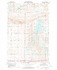
1952 Map of Tappen NE
USGS Topo · Published 1978About this map
Salt Alkaline Lake and numerous prairie potholes define the undulating terrain of this Kidder County landscape during the early 1950s. The small settlement of Ladoga sits in the southern portion of the map, positioned along the Burlington Northern railroad line which facilitated the movement of grain and goods across the North Dakota plains. The map reveals a structured rural society organized into townships such as Buckeye, Weiser, and Williams, each supporting essential local infrastructure like School No 1 and School No 2. Outdoor recreation and conservation are evident at Camp Whitney State Park on the shores of Sweetwater Lake. The distribution of these features, alongside others like Kleiter Slough, illustrates a region where water management and agriculture were the primary drivers of settlement and land use.
Find a feature on this map
15 named features on this map. Tap any name to fly to it.
Don’t see what you’re looking for? This feature index may not catch every label — zoom into the map to look around manually.
Map Details
Editions of this 1952 Tappen NE Map
2 editions found
Other maps of this area

1952 · Tappen South
USGS Topo · 1:24,000

1952 · Tappen SE
USGS Topo · 1:24,000

1952 · Tappen NE
USGS Topo · 1:24,000

1952 · Tappen North
USGS Topo · 1:24,000

1952 · New Rockford
USGS Topo · 1:250,000

1953 · Jamestown
USGS Topo · 1:250,000

1955 · Crystal Springs
USGS Topo · 1:24,000

1955 · Medina SW
USGS Topo · 1:24,000

1956 · New Rockford
USGS Topo · 1:250,000

1956 · Jamestown
USGS Topo · 1:250,000