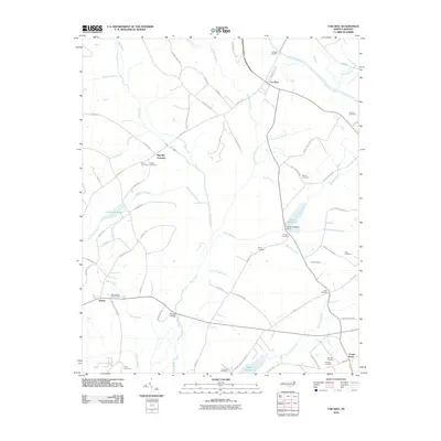
2010 Map of Tar Heel
USGS Topo · Published 2010About this map
Tar Heel Landing sits along a prominent bend in the Cape Fear River, serving as a historical point of orientation for the community of Tar Heel. The landscape is defined by an extensive network of swamps and branches, including Big Swamp, Goodman Swamp, and Tenmile Swamp, which dictate the placement of roads and homesteads. Further south, the terrain transitions into a more agricultural and industrial footprint, evidenced by Bryan Millpond and its associated Bryan Millpond Dam.
Find a feature on this map
78 named features on this map. Tap any name to fly to it.
Don’t see what you’re looking for? This feature index may not catch every label — zoom into the map to look around manually.
Map Details
Editions of this 2010 Tar Heel Map
This is the sole edition of this map. No revisions or reprints were ever made.
Other maps of this area

1953 · Florence
USGS Topo · 1:250,000

1954 · Florence
USGS Topo · 1:250,000

1955 · Elizabethtown
USGS Topo · 1:62,500

1957 · Bladenboro
USGS Topo · 1:62,500

1959 · Roseboro
USGS Topo · 1:62,500

1959 · Saint Pauls
USGS Topo · 1:62,500

1982 · Elizabethtown
USGS Topo · 1:100,000

1986 · Tar Heel
USGS Topo · 1:24,000
1986 · Bladenboro
USGS Topo · 1:24,000
1986 · Southeast Lumberton
USGS Topo · 1:24,000