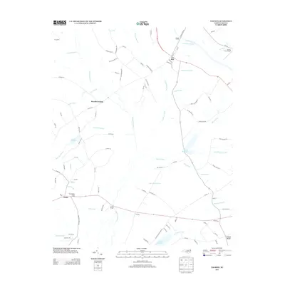
2013 Map of Tar Heel
USGS Topo · Published 2013About this map
Tar Heel sits at a historic crossing point along the Cape Fear River, where the Tar Heel Landing once served as a vital link between the waterway and the surrounding agricultural hinterland. The landscape is defined by its sophisticated drainage network, featuring the long Big Swamp Canal and Allen Pocket Canal, which transformed the natural lowlands of Huckleberry Swamp and White Oak Swamp into productive land. This era shows the continued importance of water management in the region, evidenced by the series of reservoirs and mill sites like Smiths Millpond and Hester Millpond. Small rural settlements such as Mayville Crossing and Smiths anchor the road network, while the East Robeson Lookout Tower stands as a sentinel over the extensive timber and wetlands. The inclusion of the Rocking A Farm Airport highlights the persistence of large family-owned agricultural tracts in this part of Bladen County during the early 21st century.
Find a feature on this map
97 named features on this map. Tap any name to fly to it.
Don’t see what you’re looking for? This feature index may not catch every label — zoom into the map to look around manually.
Map Details
Editions of this 2013 Tar Heel Map
This is the sole edition of this map. No revisions or reprints were ever made.
Other maps of this area

1953 · Florence
USGS Topo · 1:250,000

1954 · Florence
USGS Topo · 1:250,000

1955 · Elizabethtown
USGS Topo · 1:62,500

1957 · Bladenboro
USGS Topo · 1:62,500

1959 · Roseboro
USGS Topo · 1:62,500

1959 · Saint Pauls
USGS Topo · 1:62,500

1982 · Elizabethtown
USGS Topo · 1:100,000

1986 · Tar Heel
USGS Topo · 1:24,000
1986 · Bladenboro
USGS Topo · 1:24,000
1986 · Southeast Lumberton
USGS Topo · 1:24,000