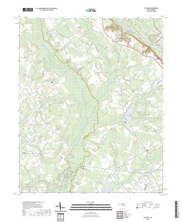
2022 Map of Tar Heel
USGS Topo · Published 2022About this map
The town of Tar Heel and the small settlement of Smiths anchor this coastal plain landscape along the border of Robeson and Bladen counties. This area is defined by a dense network of blackwater wetlands and basins, including Tenmile Swamp, Huckleberry Swamp, and White Oak Swamp. The water-dependent history of the region is evident in the presence of Hester Millpond, Bryan Millpond, and Paris Millpond, which suggest a past shaped by local milling operations. For genealogists and local historians, the sheet is particularly valuable for its documentation of numerous family burial grounds, such as the Old Pait and New Pait cemeteries, alongside Burney Cem, Grimes Cem, and Davis Cem. Large drainage projects like the Big Swamp Canal and Allen Pocket Canal intersect with natural features like Sims Pond Bay and Gum Flat Bay, illustrating long-standing efforts to manage the low-lying terrain for agriculture and habitation.
Find a feature on this map
99 named features on this map. Tap any name to fly to it.
Don’t see what you’re looking for? This feature index may not catch every label — zoom into the map to look around manually.
Map Details
Editions of this 2022 Tar Heel Map
This is the sole edition of this map. No revisions or reprints were ever made.
Other maps of this area

1953 · Florence
USGS Topo · 1:250,000

1954 · Florence
USGS Topo · 1:250,000

1955 · Elizabethtown
USGS Topo · 1:62,500

1957 · Bladenboro
USGS Topo · 1:62,500

1959 · Roseboro
USGS Topo · 1:62,500

1959 · Saint Pauls
USGS Topo · 1:62,500

1982 · Elizabethtown
USGS Topo · 1:100,000

1986 · Tar Heel
USGS Topo · 1:24,000
1986 · Bladenboro
USGS Topo · 1:24,000
1986 · Southeast Lumberton
USGS Topo · 1:24,000