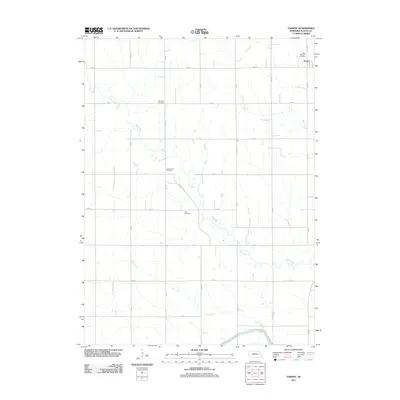
2011 Map of Tarnov
USGS Topo · Published 2011About this map
Tarnov serves as the primary settlement hub in this section of Platte County, positioned in the northeast corner where the local grid of agricultural roads converges. The landscape is defined by a complex drainage system, where the naturally meandering Shell Creek and Elm Creek are supplemented by the engineered Lost Creek Ditch and the significant Loup River Canal in the south. For genealogists and local historians, the map identifies several distinct burial grounds that mark the heritage of the area's rural communities, including Saint Michaels Cemetery, Burrows Cemetery, Greenwood Cemetery, and Zion Cemetery. The transition from natural waterways like Lost Creek to modern irrigation and drainage infrastructure reflects the intensive agricultural development of the Nebraska plains during the early 21st century.
Find a feature on this map
26 named features on this map. Tap any name to fly to it.
Don’t see what you’re looking for? This feature index may not catch every label — zoom into the map to look around manually.
Map Details
Editions of this 2011 Tarnov Map
This is the sole edition of this map. No revisions or reprints were ever made.
Other maps of this area

1896 · Stromsburg
USGS Topo · 1:125,000

1899 · David City
USGS Topo · 1:125,000

1955 · Fremont
USGS Topo · 1:250,000

1957 · Fremont
USGS Topo · 1:250,000

1958 · Fremont
USGS Topo · 1:250,000

1958 · Genoa
USGS Topo · 1:24,000

1958 · Monroe
USGS Topo · 1:24,000

1958 · Duncan
USGS Topo · 1:24,000

1966 · Tarnov
USGS Topo · 1:24,000
1966 · Lindsay SW
USGS Topo · 1:24,000