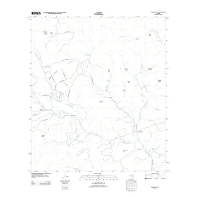
2013 Map of Tarpley
USGS Topo · Published 2013About this map
Tarpley sits at the convergence of rugged hill country hydrology and ranching infrastructure in Bandera County. The settlement is anchored by the Tarpley Cem and a network of crossings over Hondo Cr and Williams Cr. The landscape is defined by its prominent limestone peaks and deep hollows, notably Gunsight Mtn, Saddleback Mtn, and Soto Mtn. Water management for local agriculture is evident through several small impoundments, including Shadow Dance Ranch Lake and the two McClennahan Lakes. Significant drainage systems like Commissioners Cr and Winans Cr carve through the terrain, while roads such as Ranch Road 470 and Thomas Creek Rd follow the natural contours of the valley floors to connect isolated ranching properties like the Wynn Ranch.
Find a feature on this map
54 named features on this map. Tap any name to fly to it.
Don’t see what you’re looking for? This feature index may not catch every label — zoom into the map to look around manually.
Map Details
Editions of this 2013 Tarpley Map
This is the sole edition of this map. No revisions or reprints were ever made.
Other maps of this area
1954 · San Antonio
USGS Topo · 1:250,000
1956 · Tarpley
USGS Topo · 1:62,500
1956 · Tuff
USGS Topo · 1:62,500
1956 · Bandera
USGS Topo · 1:62,500
1956 · Center Point
USGS Topo · 1:62,500
1957 · San Antonio
USGS Topo · 1:250,000
1964 · Love Creek
USGS Topo · 1:24,000
1964 · Rock Cliff Reservoir
USGS Topo · 1:24,000
1964 · A Bar A Ranch
USGS Topo · 1:24,000
1964 · Tarpley
USGS Topo · 1:24,000