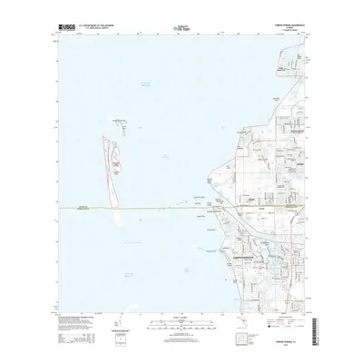
2015 Map of Tarpon Springs
USGS Topo · Published 2015About this map
The Anclote River flows into the Gulf of Mexico at the heart of this coastal study, defining the intricate shoreline of Tarpon Springs. This area is characterized by a complex network of waterways, including Kreamer Bayou, Tarpon Bayou, and Whitcomb Bayou, which integrate the town's geography with the surrounding aquatic environment. The transition from the mainland to the open gulf is marked by a series of keys and islands, most notably North Anclote Key, Dutchman Key, and Anclote Keys, creating the protected Anclote Anchorage. Northward, suburban expansion is evident in the residential layouts of Holiday, Beacon Square, and Gulf Harbors. This 2015 survey illustrates how the developed residential corridors of Pasco and Pinellas counties meet the tidal marshlands and mangrove-lined bayous of the Florida coast.
Find a feature on this map
162 named features on this map. Tap any name to fly to it.
Don’t see what you’re looking for? This feature index may not catch every label — zoom into the map to look around manually.
Map Details
Editions of this 2015 Tarpon Springs Map
This is the sole edition of this map. No revisions or reprints were ever made.
Other maps of this area

1943 · Dunedin
USGS Topo · 1:31,680

1943 · Tarpon Springs
USGS Topo · 1:31,680

1943 · Elfers
USGS Topo · 1:24,000

1943 · Oldsmar
USGS Topo · 1:24,000

1944 · Elfers
USGS Topo · 1:31,680

1944 · Oldsmar
USGS Topo · 1:31,680

1948 · Elfers
USGS Topo · 1:25,000

1954 · Port Richey
USGS Topo · 1:24,000

1955 · Plant City
USGS Topo · 1:250,000

1958 · Plant City
USGS Topo · 1:250,000