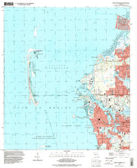
1995 Map of Tarpon Springs
USGS Topo · Published 1998About this map
The Anclote River winds through a dense landscape of residential finger canals and coastal marshes at the mid-1990s. This survey illustrates the intricate waterway systems of Tarpon Springs, where the complex shorelines of Whitcomb Bayou, Kreamer Bayou, and Spring Bayou define the urban core. Further north, the suburban expansion of Holiday and Beacon Square meets the Gulf, contrasting with the preserved natural barrier of the Anclote Keys and the Anclote Key State Preserve. Notable community landmarks include the St Petersburg Jr College campus and the Municipal Pier at Sunset Beach. The transition from industrial areas near the Powerplant to established neighborhoods like Gulf Harbors highlights the region's mid-century growth pattern and its reliance on the Intracoastal Waterway for both commerce and recreation.
Find a feature on this map
85 named features on this map. Tap any name to fly to it.
Don’t see what you’re looking for? This feature index may not catch every label — zoom into the map to look around manually.
Map Details
Editions of this 1995 Tarpon Springs Map
This is the sole edition of this map. No revisions or reprints were ever made.
Other maps of this area

1943 · Dunedin
USGS Topo · 1:31,680

1943 · Tarpon Springs
USGS Topo · 1:31,680

1943 · Elfers
USGS Topo · 1:24,000

1943 · Oldsmar
USGS Topo · 1:24,000

1944 · Elfers
USGS Topo · 1:31,680

1944 · Oldsmar
USGS Topo · 1:31,680

1948 · Elfers
USGS Topo · 1:25,000

1954 · Port Richey
USGS Topo · 1:24,000

1955 · Plant City
USGS Topo · 1:250,000

1958 · Plant City
USGS Topo · 1:250,000