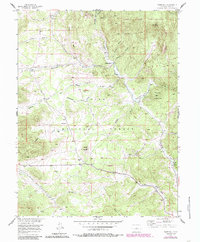
1956 Map of Tarryall
USGS Topo · Published 1985About this map
Tarryall and the surrounding high-country landscape of Park County are documented here as they appeared in the mid-1950s, with later updates reflecting the region's conservation and recreational shifts. The area is defined by the deep incisions of Tarryall Creek and its many tributaries, including Tappan Gulch and Redskin Gulch. Mining history is represented by the Boomer Mine and various gravel pits, while the ranching legacy of the region is visible through the Landis Ranch and Warlings Ranch. Significant portions of the landscape are protected within the Pike National Forest and the Lost Creek Wilderness, dominated by landmarks like the China Wall and Tappan Mountain. This survey captures the infrastructure of a working mountain landscape, from the LaSalle Pass Road to the Landing Strip and Round Mountain Campground.
Find a feature on this map
29 named features on this map. Tap any name to fly to it.
Don’t see what you’re looking for? This feature index may not catch every label — zoom into the map to look around manually.
Map Details
Editions of this 1956 Tarryall Map
4 editions found
Other maps of this area

1893 · Platte Canyon
USGS Topo · 1:125,000

1894 · Pikes Peak
USGS Topo · 1:125,000

1901 · Pikes Peak
USGS Topo · 1:125,000

1953 · Denver
USGS Topo · 1:250,000

1954 · Pueblo
USGS Topo · 1:250,000

1956 · Mc Curdy Mountain
USGS Topo · 1:24,000

1956 · Tarryall
USGS Topo · 1:24,000

1956 · Hackett Mountain
USGS Topo · 1:24,000

1956 · Lake George
USGS Topo · 1:24,000

1956 · Elevenmile Canyon
USGS Topo · 1:24,000