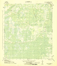
1945 Map of Tates Hell Swamp
USGS Topo · Published 1945About this map
Tates Hell Swamp dominates this 1940s landscape in Franklin County, Florida, revealing a terrain defined by its complex hydrology and industrial history. The map trace several segments of an Old Logging R.R., which provide evidence of the timber extraction that shaped this environment in the mid-20th century. These rail lines weave through the wetland, connecting remote sections of the swamp to the surrounding drainage networks. The water system is anchored by Whisky George Creek in the southwest and the New R. in the northeast, with the Big Slough Br. cutting through the northern reaches. This 1:31,680 scale survey captures the area before modern preservation efforts, documenting the specific paths of the logging industry's infrastructure across the wetlands.
Find a feature on this map
8 named features on this map. Tap any name to fly to it.
Don’t see what you’re looking for? This feature index may not catch every label — zoom into the map to look around manually.
Map Details
Editions of this 1945 Tates Hell Swamp Map
4 editions found
Other maps of this area

1943 · Carrabelle
USGS Topo · 1:24,000

1944 · Pickett Bay
USGS Topo · 1:31,680

1944 · Carrabelle
USGS Topo · 1:31,680

1944 · Green Point
USGS Topo · 1:31,680

1945 · Thousand Yard Bay
USGS Topo · 1:31,680

1945 · Tates Hell Swamp
USGS Topo · 1:31,680

1945 · Beverly
USGS Topo · 1:31,680

1945 · Pickett Bay
USGS Topo · 1:31,680

1945 · Fort Gadsden
USGS Topo · 1:31,680

1946 · Sumatra
USGS Topo · 1:31,680