
1945 Map of Tates Hell Swamp
USGS Topo · Published 1960About this map
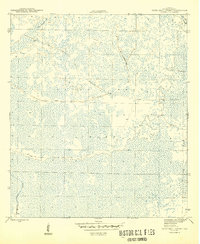
Tates Hell Swamp dominates this coastal Florida landscape, appearing here as an intricate network of wetlands and dense vegetation during the mid-1940s. The interior of this challenging terrain is defined by the remnants of the timber industry, most notably the Old Logging R. R. which once cut through the swamp to extract cypress and pine. Natural drainage features such as Big Slough and Whisky Creek provide the only consistent landmarks in a territory largely devoid of permanent human settlement. This survey, mapped by the Geological Survey in 1943, preserves the alignment of industrial transport routes before the landscape was further altered by modern drainage or conservation efforts. The presence of these specialized logging railroads highlights the importance of the lumber economy to Franklin County during this era.
Find a feature on this map
5 named features on this map. Tap any name to fly to it.
Don’t see what you’re looking for? This feature index may not catch every label — zoom into the map to look around manually.
Map Details
Editions of this 1945 Tates Hell Swamp Map
4 editions found
Historical Maps of Franklin County Through Time
121 maps found

1943 Dog Island
Franklin County, FL

1943 Indian Pass
Franklin County, FL

1943 Lighthouse Point
Franklin County, FL

1943 St. Teresa Beach
Franklin County, FL

1943 West Pass
Franklin County, FL

1944 Green Point
Franklin County, FL

1944 Pickett Bay
Franklin County, FL

1944 Sugar Hill
Franklin County, FL

1945 Beverly
Franklin County, FL

1945 Cape St. George
Franklin County, FL

1945 Fort Gadsden
Franklin County, FL

1945 Indian Pass
Franklin County, FL

1945 Lighthouse Point
Franklin County, FL

1945 Mc Intyre
Franklin County, FL

1945 Pickett Bay
Franklin County, FL

1945 St. Teresa
Franklin County, FL

1945 Sugar Hill
Franklin County, FL
1945 Tates Hell Swamp
Franklin County, FL

1950 Goose Island
Franklin County, FL

1950 New Inlet
Franklin County, FL

1981 Beverly
Franklin County, FL

1981 Fort Gadsden
Franklin County, FL

1981 Goose Island
Franklin County, FL

1981 New Inlet
Franklin County, FL

1981 Pickett Bay
Franklin County, FL

1981 St. Teresa
Franklin County, FL

1981 Sugar Hill
Franklin County, FL

1981 Tates Hell Swamp
Franklin County, FL

1982 Cape St George
Franklin County, FL

1982 Dog Island
Franklin County, FL

1982 Green Point
Franklin County, FL

1982 Indian Pass
Franklin County, FL

1982 Lighthouse Point
Franklin County, FL

1982 McIntyre
Franklin County, FL

1982 West Pass
Franklin County, FL

1994 Dog Island
Franklin County, FL

2012 Beverly
Franklin County, FL

2012 Cape Saint George
Franklin County, FL

2012 Dog Island
Franklin County, FL

2012 Fort Gadsden
Franklin County, FL

2012 Goose Island
Franklin County, FL

2012 Green Point
Franklin County, FL

2012 Indian Pass
Franklin County, FL

2012 Lighthouse Point
Franklin County, FL

2012 McIntyre
Franklin County, FL

2012 New Inlet
Franklin County, FL

2012 Pickett Bay
Franklin County, FL

2012 Saint Teresa
Franklin County, FL

2012 Sugar Hill
Franklin County, FL

2012 Tates Hell Swamp
Franklin County, FL

2012 West Pass
Franklin County, FL

2015 Beverly
Franklin County, FL

2015 Cape Saint George
Franklin County, FL

2015 Dog Island
Franklin County, FL

2015 Fort Gadsden
Franklin County, FL

2015 Goose Island
Franklin County, FL

2015 Green Point
Franklin County, FL

2015 Indian Pass
Franklin County, FL

2015 Lighthouse Point
Franklin County, FL

2015 McIntyre
Franklin County, FL

2015 New Inlet
Franklin County, FL

2015 Pickett Bay
Franklin County, FL

2015 Saint Teresa
Franklin County, FL

2015 Sugar Hill
Franklin County, FL

2015 Tates Hell Swamp
Franklin County, FL

2015 West Pass
Franklin County, FL

2018 Beverly
Franklin County, FL

2018 Cape Saint George
Franklin County, FL

2018 Dog Island
Franklin County, FL

2018 Fort Gadsden
Franklin County, FL

2018 Goose Island
Franklin County, FL

2018 Green Point
Franklin County, FL

2018 Indian Pass
Franklin County, FL

2018 Lighthouse Point
Franklin County, FL

2018 McIntyre
Franklin County, FL

2018 New Inlet
Franklin County, FL

2018 Pickett Bay
Franklin County, FL

2018 Saint Teresa
Franklin County, FL

2018 Sugar Hill
Franklin County, FL

2018 Tates Hell Swamp
Franklin County, FL

2018 West Pass
Franklin County, FL

2021 Beverly
Franklin County, FL

2021 Cape Saint George
Franklin County, FL

2021 Dog Island
Franklin County, FL

2021 Fort Gadsden
Franklin County, FL

2021 Goose Island
Franklin County, FL

2021 Green Point
Franklin County, FL

2021 Indian Pass
Franklin County, FL

2021 Lighthouse Point
Franklin County, FL

2021 McIntyre
Franklin County, FL

2021 New Inlet
Franklin County, FL

2021 Pickett Bay
Franklin County, FL

2021 Saint Teresa
Franklin County, FL

2021 Sugar Hill
Franklin County, FL

2021 Tates Hell Swamp
Franklin County, FL

2021 West Pass
Franklin County, FL

2024 Beverly
Franklin County, FL

2024 Cape Saint George
Franklin County, FL

2024 Dog Island
Franklin County, FL

2024 Fort Gadsden
Franklin County, FL

2024 Goose Island
Franklin County, FL

2024 Green Point
Franklin County, FL

2024 Indian Pass
Franklin County, FL

2024 Lighthouse Point
Franklin County, FL

2024 McIntyre
Franklin County, FL

2024 New Inlet
Franklin County, FL

2024 Pickett Bay
Franklin County, FL

2024 Saint Teresa
Franklin County, FL

2024 Sugar Hill
Franklin County, FL

2024 Tates Hell Swamp
Franklin County, FL

2024 West Pass
Franklin County, FL

2025 Cape Saint George
Franklin County, FL

2025 Dog Island
Franklin County, FL

2025 Goose Island
Franklin County, FL

2025 Indian Pass
Franklin County, FL

2025 Lighthouse Point
Franklin County, FL

2025 McIntyre
Franklin County, FL

2025 New Inlet
Franklin County, FL

2025 Saint Teresa
Franklin County, FL

2025 Sugar Hill
Franklin County, FL

2025 West Pass
Franklin County, FL