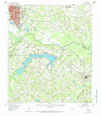
1958 Map of Tatum
USGS Topo · Published 1984About this map
Longview dominates the northwestern corner of this survey, anchored by the Le Tourneau Tech Institute and the heavy infrastructure of the Gulf Colorado and Sante Fe Railroad. The landscape is a study in East Texas industry and rural settlement, where the Sabine River snakes through the center, feeding the sprawling waters of Cherokee Lake. This reservoir is a focal point for the region, bordered by the Knox Lee Powerplant and small communities like Chalk Hill and Williams.
Find a feature on this map
69 named features on this map. Tap any name to fly to it.
Don’t see what you’re looking for? This feature index may not catch every label — zoom into the map to look around manually.
Map Details
Editions of this 1958 Tatum Map
4 editions found
Other maps of this area

1935 · Henderson
USGS Topo · 1:48,000

1936 · Kilgore
USGS Topo · 1:48,000

1939 · Henderson
USGS Topo · 1:62,500

1940 · Kilgore
USGS Topo · 1:62,500

1956 · Tyler
USGS Topo · 1:250,000

1958 · Darco
USGS Topo · 1:62,500

1958 · Carthage
USGS Topo · 1:62,500

1958 · Tatum
USGS Topo · 1:62,500

1960 · White Oak
USGS Topo · 1:24,000

1960 · Minden
USGS Topo · 1:62,500