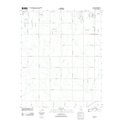
2012 Map of Taupa
USGS Topo · Published 2012About this map
Goodyear Plant stands as a massive industrial landmark on this landscape east of Cache, defining the economic corridor of the early 21st century. The map reveals a transition between the developed outskirts of Taupa and the surrounding rural plains, where aviation and agriculture intersect at Huscher Field Airport. Several burial grounds, including Deyo Cem, Pecan Cem, and the Sunset Memorial Garden Cem, are positioned along the section-line roads, serving as significant nodes for local genealogical research. The drainage network is clearly articulated by the meandering paths of Blue Beaver Cr, Pecan Cr, and W Cache Cr, which flow toward the southern reaches of Comanche County. The inclusion of Lake Unity and the local road grid, with names like SW Deyo Mission Rd, reflects the area's continued integration of modern infrastructure with historical mission-era geography.
Find a feature on this map
61 named features on this map. Tap any name to fly to it.
Don’t see what you’re looking for? This feature index may not catch every label — zoom into the map to look around manually.
Map Details
Editions of this 2012 Taupa Map
This is the sole edition of this map. No revisions or reprints were ever made.
Other maps of this area

1937 · Cache
USGS Topo · 1:48,000

1937 · Quanah Mountain
USGS Topo · 1:24,000

1942 · Cache
USGS Topo · 1:62,500

1946 · Lawton
USGS Topo · 1:62,500

1949 · Mount Scott
USGS Topo · 1:24,000

1949 · Quanah Mountain
USGS Topo · 1:24,000

1949 · Fort Sill
USGS Topo · 1:24,000

1955 · Lawton
USGS Topo · 1:250,000

1956 · Post Oak Creek
USGS Topo · 1:24,000
1956 · Quanah Mountain
USGS Topo · 1:24,000