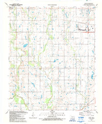
1991 Map of Taupa
USGS Topo · Published 1992About this map
Blue Beaver Creek and Pecan Creek drain this section of the Oklahoma plains south of the Wichita Mountains. The landscape is defined by its rural church and cemetery network, including sites like Deyo Chapel and the nearby Deyo Cem. In the northwest, the Cache corporate boundary marks the edge of the growing settlement near West Cache Creek, while the eastern portion of the map features the community of Taupa.
Find a feature on this map
18 named features on this map. Tap any name to fly to it.
Don’t see what you’re looking for? This feature index may not catch every label — zoom into the map to look around manually.
Map Details
Editions of this 1991 Taupa Map
This is the sole edition of this map. No revisions or reprints were ever made.
Other maps of this area

1937 · Cache
USGS Topo · 1:48,000

1937 · Quanah Mountain
USGS Topo · 1:24,000

1942 · Cache
USGS Topo · 1:62,500

1946 · Lawton
USGS Topo · 1:62,500

1949 · Mount Scott
USGS Topo · 1:24,000

1949 · Quanah Mountain
USGS Topo · 1:24,000

1949 · Fort Sill
USGS Topo · 1:24,000

1955 · Lawton
USGS Topo · 1:250,000

1956 · Post Oak Creek
USGS Topo · 1:24,000
1956 · Quanah Mountain
USGS Topo · 1:24,000