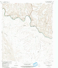
1983 Map of Taylor Canyon
USGS Topo · Published 1984About this map
The Rio Grande Rio Bravo carves a deep international boundary through the arid canyonlands of Terrell County and the Mexican state of Coahuila. Compiled from mid-1970s aerial photography, this survey documents the isolated terrain where the river serves as both a physical barrier and a vital water source at points like Middle Watering and Paso Colorado. The landscape is dominated by complex drainage systems and high ridges, including the Sierra Cuchilla La Chulita and the steep Lomas Cuesta el Muerto. Remote human activity is evidenced by several Landing Strips and essential water features such as Chupaderos las Palmas Spring and Huisache Well, which sustained livestock and travelers in this high-desert environment before the further modernization of the border region.
Find a feature on this map
34 named features on this map. Tap any name to fly to it.
Don’t see what you’re looking for? This feature index may not catch every label — zoom into the map to look around manually.
Map Details
Editions of this 1983 Taylor Canyon Map
This is the sole edition of this map. No revisions or reprints were ever made.
Other maps of this area

1918 · Dryden Crossing
USGS Topo · 1:62,500

1918 · Indian Wells
USGS Topo · 1:62,500

1959 · Emory Peak
USGS Topo · 1:250,000

1965 · Emory Peak
USGS Topo · 1:250,000
1983 · Panther Gulch East
USGS Topo · 1:24,000
1983 · Balcon Creek
USGS Topo · 1:24,000
1983 · Candilla Canyon East
USGS Topo · 1:24,000
1983 · McClain Canyon
USGS Topo · 1:24,000
1983 · Shafter Canyon
USGS Topo · 1:24,000
1985 · Dove Mountain
USGS Topo · 1:100,000