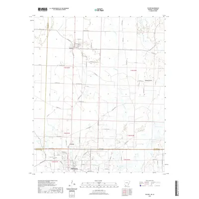
2020 Map of Taylor
USGS Topo · Published 2020About this map
The borderlands of the Arkansas-Louisiana state line define this region, where the town of Taylor sits just north of the boundary and the larger center of Springhill anchor the southern portion in Webster Parish. This geography is shaped by the drainage systems of Bayou Dorcheat and its various tributaries, including Little Crooked Cr and Crooked Cr. The landscape transitions from the grid-like residential streets of Springhill, such as North Ave and E Pine St, to the more dispersed rural settlements of Welcome and Walnut Grove. Local history is anchored by sites like Springhill Cem, while the hydrology of the area is further marked by Sandlin Lake and Keoun Cr. The map illustrates a modern road network crossing historical township lines, reflecting the enduring patterns of timber and agricultural movement across the state line.
Find a feature on this map
83 named features on this map. Tap any name to fly to it.
Don’t see what you’re looking for? This feature index may not catch every label — zoom into the map to look around manually.
Map Details
Editions of this 2020 Taylor Map
This is the sole edition of this map. No revisions or reprints were ever made.
Other maps of this area

1922 · Sarepta
USGS Topo · 1:62,500

1924 · Sarepta
USGS Topo · 1:62,500

1950 · Plain Dealing NE
USGS Topo · 1:31,680

1952 · Bradley NE
USGS Topo · 1:24,000

1952 · Bradley SE
USGS Topo · 1:24,000

1953 · Carterville
USGS Topo · 1:24,000

1953 · El Dorado
USGS Topo · 1:250,000

1955 · Shreveport
USGS Topo · 1:250,000
1955 · Plain Dealing
USGS Topo · 1:62,500

1956 · Shreveport
USGS Topo · 1:250,000