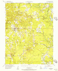
1955 Map of Plain Dealing
USGS Topo · Published 1956About this map
Plain Dealing serves as the central hub of this northern Bossier Parish landscape, situated at the intersection of the St Louis Southwestern railroad and several local roads. The mid-century economy is clearly defined by extensive energy extraction, with the Plain Dealing Oil Field, Redland Oil and Gas Field, and Sarepta Gas and Oil Field dominating the township grids. Beyond the industrial zones, the area is heavily dotted with rural community markers such as Old Rock Spring Ch, Elizabeth Sch, and the Rocky Mount Cem. To the west, Delaney Mt rises near the parish line, while the eastern border is defined by the winding course of Bodcau Bayou. The map also captures the transition of transportation, noting an Old Railroad Grade and the Crossway through the southern bottoms, illustrating how local travel patterns evolved around the bayous and oil fields.
Find a feature on this map
87 named features on this map. Tap any name to fly to it.
Don’t see what you’re looking for? This feature index may not catch every label — zoom into the map to look around manually.
Map Details
Editions of this 1955 Plain Dealing Map
4 editions found
Other maps of this area

1922 · Sarepta
USGS Topo · 1:62,500

1924 · Sarepta
USGS Topo · 1:62,500

1932 · Hosston NE
USGS Topo · 1:31,680

1932 · Bossier NE
USGS Topo · 1:31,680

1932 · Hosston SE
USGS Topo · 1:31,680

1932 · Bossier NW
USGS Topo · 1:31,680

1932 · Shreveport NE
USGS Topo · 1:31,680

1947 · Minden
USGS Topo · 1:62,500

1948 · Mooringsport
USGS Topo · 1:62,500

1948 · Vivian
USGS Topo · 1:62,500