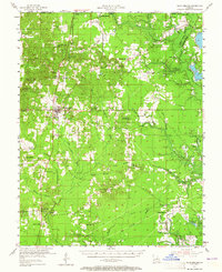
1955 Map of Plain Dealing
USGS Topo · Published 1965About this map
The St Louis Southwestern Railroad anchors this mid-century portrait of Bossier Parish, connecting timber and oil towns like Bolinger, Antrim, and Plain Dealing. This era shows a landscape undergoing industrial transition, where several designated petroleum districts like the Plain Dealing Oil Field and Sarepta Gas and Oil Field overlap with traditional agrarian settlements. Rural life is evidenced by a dense network of local landmarks, including the Elizabeth Sch and Louisville Sch, alongside numerous country sanctuaries such as Macedonia Ch and Aimwell Ch.
Find a feature on this map
71 named features on this map. Tap any name to fly to it.
Don’t see what you’re looking for? This feature index may not catch every label — zoom into the map to look around manually.
Map Details
Editions of this 1955 Plain Dealing Map
4 editions found
Other maps of this area

1922 · Sarepta
USGS Topo · 1:62,500

1924 · Sarepta
USGS Topo · 1:62,500

1932 · Hosston NE
USGS Topo · 1:31,680

1932 · Bossier NE
USGS Topo · 1:31,680

1932 · Hosston SE
USGS Topo · 1:31,680

1932 · Bossier NW
USGS Topo · 1:31,680

1932 · Shreveport NE
USGS Topo · 1:31,680

1947 · Minden
USGS Topo · 1:62,500

1948 · Mooringsport
USGS Topo · 1:62,500

1948 · Vivian
USGS Topo · 1:62,500