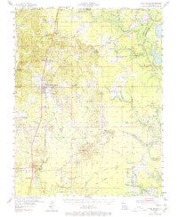
1955 Map of Plain Dealing
USGS Topo · Published 1978About this map
Plain Dealing serves as the focal point for this mid-century survey of northern Bossier Parish, situated along the St Louis Southwestern Railroad. The landscape is defined by a dense network of energy production, including the Plain Dealing Oil Field and the Sarepta Gas and Oil Field to the east. The terrain is characterized by the meandering Bayou Bodcau and the Bayou Bodcau Reservoir, which dominate the eastern border. Evidence of local community life is scattered throughout the rural sections, from the Louisville Sch near Collinsburg to the remote Chalybeate Springs near the Arkansas border. Genealogists can find numerous family-named landmarks and cemeteries, such as Smith-Gillean Cem and Rogers Cem, alongside specialized structures like the Plain Dealing Lookout Tower. The map also preserves traces of older transit routes, noting an Old Railroad Grade passing through the settlement of Ivan.
Find a feature on this map
71 named features on this map. Tap any name to fly to it.
Don’t see what you’re looking for? This feature index may not catch every label — zoom into the map to look around manually.
Map Details
Editions of this 1955 Plain Dealing Map
4 editions found
Other maps of this area

1922 · Sarepta
USGS Topo · 1:62,500

1924 · Sarepta
USGS Topo · 1:62,500

1932 · Hosston NE
USGS Topo · 1:31,680

1932 · Bossier NE
USGS Topo · 1:31,680

1932 · Hosston SE
USGS Topo · 1:31,680

1932 · Bossier NW
USGS Topo · 1:31,680

1932 · Shreveport NE
USGS Topo · 1:31,680

1947 · Minden
USGS Topo · 1:62,500

1948 · Mooringsport
USGS Topo · 1:62,500

1948 · Vivian
USGS Topo · 1:62,500