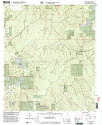
2000 Map of Taylor Hill
USGS Topo · Published 2003About this map
De Soto National Forest dominates the landscape of Perry County, Mississippi, in this revision based on late-20th-century data. The terrain is defined by a dense network of drainages, including the whimsically named Shut Eye Creek and Whiskey Creek, which carve through the pine-belt topography. Small clearings for human activity appear primarily along the New Augusta - Wiggins Road and Seed Orchard Road, where the community of Oak Grove and landmarks like the Cypress Creek Ch provide focal points for local history.
Find a feature on this map
33 named features on this map. Tap any name to fly to it.
Don’t see what you’re looking for? This feature index may not catch every label — zoom into the map to look around manually.
Map Details
Editions of this 2000 Taylor Hill Map
This is the sole edition of this map. No revisions or reprints were ever made.
Other maps of this area

1947 · Beaumont
USGS Topo · 1:62,500

1947 · Wiggins
USGS Topo · 1:62,500

1947 · New Augusta
USGS Topo · 1:62,500

1947 · Benndale
USGS Topo · 1:62,500

1949 · Wiggins
USGS Topo · 1:62,500

1949 · Beaumont
USGS Topo · 1:62,500

1949 · New Augusta
USGS Topo · 1:62,500

1949 · Benndale
USGS Topo · 1:62,500

1953 · Hattiesburg
USGS Topo · 1:250,000

1953 · Mobile
USGS Topo · 1:250,000