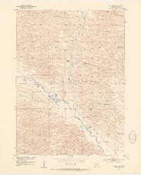
1952 Map of Taylor NE
USGS Topo · Published 1954About this map
The Calamus River defines the central topography of this Sandhills landscape, creating a fertile corridor for cattle ranching and early aviation in Loup County. The river’s path is flanked by numerous family-named establishments, including Chapman Ranch, Schonhar Ranch, and River Ranch, which speak to the area’s agricultural heritage in the early 1950s. A notable Landing Field positioned near the riverbank suggests the logistical importance of small-scale aviation for these isolated properties.
Find a feature on this map
17 named features on this map. Tap any name to fly to it.
Don’t see what you’re looking for? This feature index may not catch every label — zoom into the map to look around manually.
Map Details
Editions of this 1952 Taylor NE Map
2 editions found
Other maps of this area

1952 · Burwell
USGS Topo · 1:24,000

1952 · Taylor NW
USGS Topo · 1:24,000

1952 · Taylor SE
USGS Topo · 1:24,000

1952 · Taylor
USGS Topo · 1:24,000

1952 · Burwell NW
USGS Topo · 1:24,000

1952 · Taylor NE
USGS Topo · 1:24,000

1955 · Broken Bow
USGS Topo · 1:250,000

1955 · O'Neill
USGS Topo · 1:250,000

1956 · Broken Bow
USGS Topo · 1:250,000

1959 · O'Neill
USGS Topo · 1:250,000