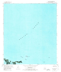
1971 Map of Taylor Pass
USGS Topo · Published 1974About this map
Breton Sound dominates this coastal orthophotomap, showing the delicate marine environment of Plaquemines Parish in the early 1970s. The landscape is defined by the transition from open water to marshy fragments, with Bird Island sitting as a lonely landmark within the tidal expanse. As an orthophotomap, this sheet provides a photographic record of the shifting silt and shallows of the Mississippi River Delta, where the entire land area is noted as being below five feet in elevation. Significant industrial activity is visible through the presence of an Oil Well and various Platforms scattered across the water, marking the intersection of the Gulf's natural ecology and Louisiana's energy economy. Navigational channels like Taylor Pass and the sheltered waters of Grand Bay illustrate the hydraulic complexity of this subsiding shoreline.
Find a feature on this map
6 named features on this map. Tap any name to fly to it.
Don’t see what you’re looking for? This feature index may not catch every label — zoom into the map to look around manually.
Map Details
Editions of this 1971 Taylor Pass Map
This is the sole edition of this map. No revisions or reprints were ever made.
Other maps of this area

1893 · La Fortuna
USGS Topo · 1:62,500

1893 · Forts
USGS Topo · 1:62,500

1935 · Taylor Pass
USGS Topo · 1:31,680

1947 · Venice
USGS Topo · 1:31,680

1947 · Fort St. Philip
USGS Topo · 1:31,680

1947 · Main Pass
USGS Topo · 1:31,680

1948 · Forts
USGS Topo · 1:62,500
1949 · Coquille Point
USGS Topo · 1:31,680
1950 · Breton Islands
USGS Topo · 1:24,000

1953 · Breton Island
USGS Topo · 1:62,500