
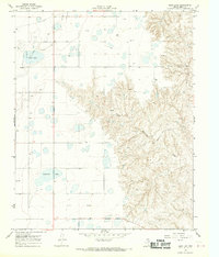
1968 Map of Taylor Ranch
USGS Topo · Published 1969About this map
Gas and Oil Field operations define the economy of this Gray County landscape during the late 1960s. The terrain is marked by a complex network of industrial infrastructure, including a prominent Pipeline, multiple Gas Wells, and Pumping Stations that speak to the region's petroleum development. Amidst these energy works, the drainage of North McClellan Creek and Turkey Creek provides the primary natural structure to the topography, winding through the ranching and resource lands.
Find a feature on this map
16 named features on this map. Tap any name to fly to it.
Don’t see what you’re looking for? This feature index may not catch every label — zoom into the map to look around manually.
Map Details
Editions of this 1968 Taylor Ranch Map
This is the sole edition of this map. No revisions or reprints were ever made.
Other maps of this area

1954 · Amarillo
USGS Topo · 1:250,000

1958 · Amarillo
USGS Topo · 1:250,000

1962 · Hudgens Ranch
USGS Topo · 1:24,000

1962 · Pond Creek NW
USGS Topo · 1:24,000

1963 · Alanreed
USGS Topo · 1:24,000

1964 · Jericho
USGS Topo · 1:24,000

1964 · Rockledge
USGS Topo · 1:24,000

1966 · Bowers City
USGS Topo · 1:24,000

1967 · Lefors
USGS Topo · 1:24,000
1968 · Deep Lake
USGS Topo · 1:24,000