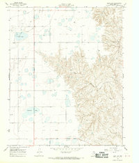
1968 Map of Deep Lake
USGS Topo · Published 1970About this map
The Oil Field of Gray County dominates this 1968 landscape, where industrial development meets the depressions of the Texas Panhandle. The terrain is defined by its hydrology and mineral extraction, centered on Deep Lake and the nearby Wakefield Lake. These water bodies sit within a broader network of numerous Gas Wells and Oil Wells that punctuate the plains, connected by a network of unimproved roads and a major Pipeline in the northwest. To the east, the topography shifts dramatically as the flat upland breaks into the drainage basin of North McClellan Creek. This transition from high plains to dissected creek valleys illustrates the dual character of the region during the late 1960s, balancing intensive energy production with the natural seasonal drainage patterns of the Llano Estacado. Small-scale resource extraction is also evident at a Gravel Pit located near the edge of the creek breaks.
Find a feature on this map
9 named features on this map. Tap any name to fly to it.
Don’t see what you’re looking for? This feature index may not catch every label — zoom into the map to look around manually.
Map Details
Editions of this 1968 Deep Lake Map
This is the sole edition of this map. No revisions or reprints were ever made.
Other maps of this area

1954 · Amarillo
USGS Topo · 1:250,000

1958 · Amarillo
USGS Topo · 1:250,000

1960 · Groom
USGS Topo · 1:62,500

1964 · Jericho
USGS Topo · 1:24,000

1964 · Rockledge
USGS Topo · 1:24,000

1966 · Grandview School
USGS Topo · 1:24,000

1966 · Kingsmill
USGS Topo · 1:24,000

1966 · Bowers City
USGS Topo · 1:24,000

1967 · Lefors
USGS Topo · 1:24,000

1968 · Taylor Ranch
USGS Topo · 1:24,000