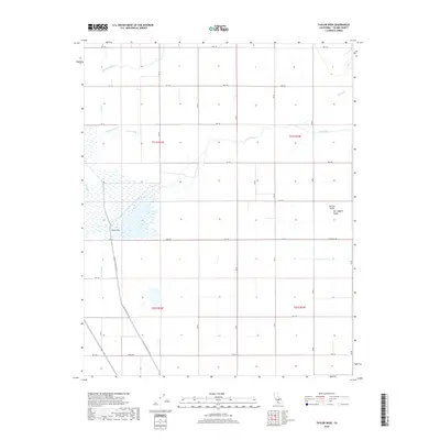
2018 Map of Taylor Weir
USGS Topo · Published 2018About this map
The Tule River meanders across this Tulare County landscape, reflecting an intricate network of agricultural water management in the San Joaquin Valley. At its heart lies the eponymous Taylor Weir, a critical point of water diversion that defines the local irrigation infrastructure. This system is further articulated by the Taylor Canal and the Bayou Vista Side Ditch, which channel water south through the Central Valley floor. The hydrology here is complex, featuring the branching of N Fork Deep Cr and S Fork Deep Cr alongside natural drainage features like Bates Slough and Elk Bayou. The grid-like road system, defined by corridors such as Ave 144 and Elk Bayou Rd, illustrates the highly organized parceling of land for large-scale cultivation.
Find a feature on this map
34 named features on this map. Tap any name to fly to it.
Don’t see what you’re looking for? This feature index may not catch every label — zoom into the map to look around manually.
Map Details
Editions of this 2018 Taylor Weir Map
This is the sole edition of this map. No revisions or reprints were ever made.
Other maps of this area
1914 · Lost Hills
USGS Topo · 1:125,000
1925 · Tulare
USGS Topo · 1:31,680
1925 · Tipton
USGS Topo · 1:31,680
1927 · Lake View School
USGS Topo · 1:31,680
1927 · Paige
USGS Topo · 1:31,680
1927 · Tulare
USGS Topo · 1:31,680
1928 · Tipton
USGS Topo · 1:31,680
1928 · Waukena
USGS Topo · 1:31,680
1928 · Corcoran
USGS Topo · 1:31,680
1929 · Alpaugh
USGS Topo · 1:31,680