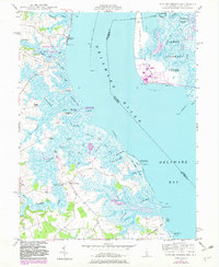
1948 Map of Taylors Bridge
USGS Topo · Published 1983About this map
Cedar Swamp and the tidal reaches of the Delaware River dominate this coastal survey, which highlights the transition from 1940s topography to early 1980s industrial development. The small community of Taylors Bridge sits at the head of a complex network of marshland drainage, including the Big Ditch and White Oak Ditch. The shoreline is marked by historic landings such as Thomas Landing, Fennimore Landing, and Stave Landing, points that once served the river-based economy of New Castle County. Across the water in New Jersey, the 1981 revisions show a massive powerplant on Artificial Island, contrasting with the preserved wetlands of the Augustine Wildlife Area and Appoquinimink Wildlife Area. The landscape is a detailed record of coastal drainage patterns, from Augustine Creek in the north to the meandering path of Blackbird Creek in the south.
Find a feature on this map
55 named features on this map. Tap any name to fly to it.
Don’t see what you’re looking for? This feature index may not catch every label — zoom into the map to look around manually.
Map Details
Editions of this 1948 Taylors Bridge Map
3 editions found
Other maps of this area

1890 · Salem
USGS Topo · 1:62,500

1890 · Bay Side
USGS Topo · 1:62,500

1894 · Bay Side
USGS Topo · 1:62,500

1898 · Salem
USGS Topo · 1:62,500

1899 · Vineland
USGS Topo · 1:125,000

1899 · Dover
USGS Topo · 1:125,000

1901 · Camden
USGS Topo · 1:125,000

1904 · Wilmington
USGS Topo · 1:62,500

1906 · Dover
USGS Topo · 1:125,000

1906 · Wilmington
USGS Topo · 1:62,500
Featured Places
- Lower Alloways Creek Township, NJ
- Fennimore Landing, DE
- Elsinboro Township, NJ
- Stave Landing, DE
- The Island, DE