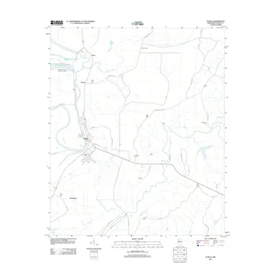
2012 Map of Tchula
USGS Topo · Published 2012About this map
The town of Tchula and the nearby community of Gwin serve as the primary hubs in this part of the Mississippi Delta, defined by a landscape of curving waterways and numerous burial sites. The oxbow of Tchula Lake and the waters of Horseshoe Lake dominate the northwestern quadrant, where the Southland Flying Service Inc. Airport highlights the agricultural aviation history of the region. Local heritage is preserved in a dense network of family and community resting places, including Wyatt Cem, Cunliff Cem, and Saint Johns Cem. The map illustrates the transition from the low-lying bayous near Millstone Bayou and Fannegusha Cr to the more structured roads of Holmes County, such as Hillside Levee Rd. Smaller settlements like Oswego, Wyatt, and Shackleford are connected by a system of rural routes and the presence of the Railroad St corridor in Gwin, marking the area's historical reliance on rail transportation.
Find a feature on this map
66 named features on this map. Tap any name to fly to it.
Don’t see what you’re looking for? This feature index may not catch every label — zoom into the map to look around manually.
Map Details
Editions of this 2012 Tchula Map
This is the sole edition of this map. No revisions or reprints were ever made.
Other maps of this area

1940 · Seven Pines
USGS Topo · 1:62,500

1940 · Lexington
USGS Topo · 1:62,500

1940 · Mileston
USGS Topo · 1:62,500

1953 · Greenwood
USGS Topo · 1:250,000

1954 · Mileston
USGS Topo · 1:62,500

1956 · Greenwood
USGS Topo · 1:250,000

1957 · Lexington
USGS Topo · 1:62,500

1957 · Seven Pines
USGS Topo · 1:62,500

1958 · Seven Pines
USGS Topo · 1:62,500

1958 · Lexington
USGS Topo · 1:62,500