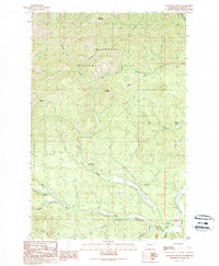
1989 Map of Teanaway
USGS Topo · Published 1989About this map
Wenatchee National Forest dominates this Kittitas County landscape, where the headwaters of the Teanaway River system carve through steep ridges and timberland. The confluence of the Middle Fork Teanaway River and the West Fork Teanaway River provides a focal point for the region's geography, with the North Fork Teanaway River appearing in the southeastern corner. Historical activity is centered near Casland (Site) and the Teanaway Campground, marking a transition from the lower river valleys to the higher elevations of Cle Elum Ridge. High points such as Malcolm Mountain, Yellow Hill, and Teanaway Butte offer significant landmarks for those tracing the topographic relief of the Cascades. Local recreational and utility features, including the Indian Camp Campground and Liars Prairie, are documented alongside numerous drainage creeks like Jungle Creek and Lick Creek, illustrating the intricate water network that defines this high-country terrain.
Find a feature on this map
27 named features on this map. Tap any name to fly to it.
Don’t see what you’re looking for? This feature index may not catch every label — zoom into the map to look around manually.
Map Details
Editions of this 1989 Teanaway Map
This is the sole edition of this map. No revisions or reprints were ever made.
Other maps of this area

1897 · Mount Stuart
USGS Topo · 1:125,000

1902 · Mount Stuart
USGS Topo · 1:125,000

1957 · Wenatchee
USGS Topo · 1:250,000

1958 · Thorp
USGS Topo · 1:24,000

1958 · Thorp
USGS Topo · 1:62,500

1958 · Cle Elum
USGS Topo · 1:62,500

1961 · Liberty
USGS Topo · 1:62,500

1961 · Mount Stuart
USGS Topo · 1:62,500

1975 · Wenatchee
USGS Topo · 1:100,000
1984 · Cle Elum
USGS Topo · 1:24,000