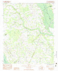
1983 Map of Tearcoat Branch
USGS Topo · Published 1983About this map
The Black River Swamp and the headwaters of the Pocotaligo River define this rural landscape on the border of Sumter and Clarendon counties. In the early 1980s, the area remained characterized by small agrarian communities and numerous country churches, reflecting a deeply rooted local social fabric. Notable congregations include Congruity Ch in the north and Green Hill Ch near the southern boundary, while family landmarks like Brunsons Cem provide vital clues for genealogical research.
Find a feature on this map
23 named features on this map. Tap any name to fly to it.
Don’t see what you’re looking for? This feature index may not catch every label — zoom into the map to look around manually.
Map Details
Editions of this 1983 Tearcoat Branch Map
This is the sole edition of this map. No revisions or reprints were ever made.
Other maps of this area

1920 · Mayesville
USGS Topo · 1:48,000

1920 · Manning
USGS Topo · 1:48,000

1921 · Manning
USGS Topo · 1:62,500

1921 · Mayesville
USGS Topo · 1:62,500

1943 · Mayesville
USGS Topo · 1:62,500

1944 · Manning
USGS Topo · 1:62,500

1946 · Sumter
USGS Topo · 1:62,500

1954 · Augusta
USGS Topo · 1:250,000

1957 · Sumter East
USGS Topo · 1:24,000

1957 · Sumter
USGS Topo · 1:62,500