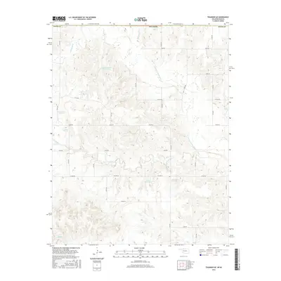
2016 Map of Tegarden NE
USGS Topo · Published 2016About this map
The Salt Fork Arkansas River carves a winding path through this northern Woods Co landscape, defining the local hydrology alongside numerous named tributaries. The terrain is marked by an extensive network of drainage systems, including Yellowstone Cr, Hackberry Cr, and Greenleaf Cr. This 2016 survey illustrates a rural environment heavily modified for water management, featuring several privately-named water bodies such as Isenhart Number 1 Reservoir, Oakes Number 1 Reservoir, and Cravens Reservoir. The systematic road grid, consisting of routes like Osage Rd and Logan Rd, reveals the enduring structure of the Public Land Survey System. A unique natural feature, Buffalo Spring, is tucked away in the eastern portion of the quadrangle, while the southern reaches are drained by Boggy Cr.
Find a feature on this map
30 named features on this map. Tap any name to fly to it.
Don’t see what you’re looking for? This feature index may not catch every label — zoom into the map to look around manually.
Map Details
Editions of this 2016 Tegarden NE Map
This is the sole edition of this map. No revisions or reprints were ever made.
Other maps of this area
1891 · Medicine Lodge
USGS Topo · 1:125,000
1893 · Medicine Lodge
USGS Topo · 1:125,000
1955 · Woodward
USGS Topo · 1:250,000
1955 · Pratt
USGS Topo · 1:250,000
1958 · Woodward
USGS Topo · 1:250,000
1959 · Pratt
USGS Topo · 1:250,000
1969 · Tegarden NE
USGS Topo · 1:24,000
1969 · Tegarden SE
USGS Topo · 1:24,000
1969 · Tegarden NW
USGS Topo · 1:24,000
1969 · Alva NW
USGS Topo · 1:24,000