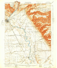
1905 Map of Tehama
USGS Topo · Published 1932About this map
The Sacramento River carves a deep path through Tehama County, serving as the central artery for this 1903 survey area. The landscape is defined by the transition from the broad alluvial fans of the Las Flores Plains and Saucos to the dramatic uplift of the Abraham Plains and Mud Springs Plains in the east. Regional industry is anchored by the Southern Pacific R. R. (Portland Line) which connects the town of Red Bluff to southern points like Tehama and Sesma.
Find a feature on this map
63 named features on this map. Tap any name to fly to it.
Don’t see what you’re looking for? This feature index may not catch every label — zoom into the map to look around manually.
Map Details
Editions of this 1905 Tehama Map
4 editions found
Other maps of this area

1886 · Lassen Peak
USGS Topo · 1:250,000

1890 · Red Bluff
USGS Topo · 1:250,000

1891 · Chico
USGS Topo · 1:125,000

1892 · Lassen Peak
USGS Topo · 1:250,000

1893 · Chico
USGS Topo · 1:125,000

1894 · Lassen Peak
USGS Topo · 1:250,000

1894 · Red Bluff
USGS Topo · 1:250,000

1895 · Chico
USGS Topo · 1:125,000

1904 · Vina
USGS Topo · 1:62,500

1905 · Tehama
USGS Topo · 1:62,500