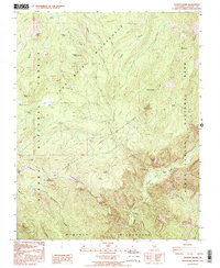
1992 Map of Tehipite Dome
USGS Topo · Published 1995About this map
Tehipite Dome stands as a massive granite landmark above the Tehipite Valley, marking a point where the high wilderness of the Sierra National Forest meets the northern reaches of Kings Canyon National Park. This 1990s provisional survey documents a landscape defined by deep glacial canyons and prominent ridges, including Tombstone Ridge and Kettle Ridge. The Middle Fork Kings River carves through the lower half of the sheet, joined by tributaries such as Silver Creek and Crown Creek. While the terrain is largely protected wilderness, human activity is noted at the Crown Valley Station and the Randle Corral, reflecting the long-standing use of these meadows for seasonal livestock and backcountry management. Significant peaks like Castle Peak and the high elevation Elizabeth Lake define the northern boundary, illustrating the transition from forested basins to high alpine meadows like Large Meadow.
Find a feature on this map
40 named features on this map. Tap any name to fly to it.
Don’t see what you’re looking for? This feature index may not catch every label — zoom into the map to look around manually.
Map Details
Editions of this 1992 Tehipite Dome Map
This is the sole edition of this map. No revisions or reprints were ever made.
Other maps of this area

1903 · Tehipite
USGS Topo · 1:125,000

1905 · Tehipite
USGS Topo · 1:125,000

1912 · Mt. Goddard
USGS Topo · 1:125,000

1947 · Mariposa
USGS Topo · 1:250,000

1948 · Fresno
USGS Topo · 1:250,000

1948 · Mariposa
USGS Topo · 1:250,000

1948 · Mt. Goddard
USGS Topo · 1:62,500

1951 · Mt. Goddard
USGS Topo · 1:62,500

1952 · Mt. Goddard
USGS Topo · 1:62,500

1952 · Tehipite Dome
USGS Topo · 1:62,500