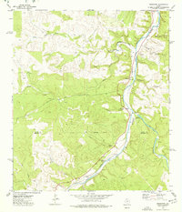
1974 Map of Telegraph
USGS Topo · Published 1977About this map
The South Llano River carves a dominant path through the Edwards Plateau in the mid-1970s, defining a landscape where ranching and remote aviation intersect. The tiny settlement of Telegraph serves as a focal point along the river, flanked by a linear Landing Strip that underscores the reliance on private aircraft in this isolated region. The map highlights several critical water sources essential for livestock and habitation, including the distinctive Seven Hundred Springs and Bowie Spring.
Find a feature on this map
33 named features on this map. Tap any name to fly to it.
Don’t see what you’re looking for? This feature index may not catch every label — zoom into the map to look around manually.
Map Details
Editions of this 1974 Telegraph Map
This is the sole edition of this map. No revisions or reprints were ever made.
Other maps of this area

1893 · Rock Springs
USGS Topo · 1:125,000

1926 · Segovia 2-c
USGS Topo · 1:48,000

1932 · Junction
USGS Topo · 1:62,500

1954 · Llano
USGS Topo · 1:250,000

1954 · Sonora
USGS Topo · 1:250,000

1955 · Llano
USGS Topo · 1:250,000

1956 · Llano
USGS Topo · 1:250,000

1958 · Sonora
USGS Topo · 1:250,000

1962 · Hill Ranch
USGS Topo · 1:24,000

1962 · Roosevelt
USGS Topo · 1:24,000