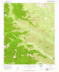
1956 Map of Telegraph Peak
USGS Topo · Published 1961About this map
Wrightwood sits at the edge of Swarthout Valley, serving as a focal point for this high-altitude landscape in the San Bernardino Mountains. The 1950s terrain is marked by a transition from organized ranching at Nuss Ranch and Nielson Ranch to the protected wilderness of the Cucamonga Wild Area and San Bernardino National Forest. Local heritage is anchored by the Pioneer Historic Marker near Cajon Canyon, signaling the importance of these mountain passes.
Find a feature on this map
38 named features on this map. Tap any name to fly to it.
Don’t see what you’re looking for? This feature index may not catch every label — zoom into the map to look around manually.
Map Details
Editions of this 1956 Telegraph Peak Map
4 editions found
Other maps of this area

1896 · San Bernardino
USGS Topo · 1:62,500

1897 · Cucamonga
USGS Topo · 1:62,500

1898 · San Bernardino
USGS Topo · 1:62,500

1900 · Cucamonga
USGS Topo · 1:62,500

1901 · Southern California Sheet No. 1
USGS Topo · 1:250,000

1901 · San Bernardino
USGS Topo · 1:62,500

1902 · Hesperia
USGS Topo · 1:62,500

1903 · Cucamonga
USGS Topo · 1:62,500

1903 · San Antonio
USGS Topo · 1:62,500

1904 · Southern California Sheet No. 1
USGS Topo · 1:250,000