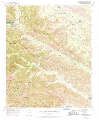
1956 Map of Telegraph Peak
USGS Topo · Published 1969About this map
Swarthout Valley and the high ridges of the San Gabriel Mountains dominate this topographic study, which captures the region as it transitioned through the mid-1950s with late-1960s updates. The dramatic geology of the San Andreas Rift Zone bisects the terrain, creating a complex landscape of deep canyons and sharp peaks like Telegraph Peak and Thunder Mtn. The settlement of Wrightwood is visible in the northwest, while several family-held sites including Nuss Ranch, Clyde Ranch, and Nielson Ranch are scattered along the canyons and jeep trails.
Find a feature on this map
43 named features on this map. Tap any name to fly to it.
Don’t see what you’re looking for? This feature index may not catch every label — zoom into the map to look around manually.
Map Details
Editions of this 1956 Telegraph Peak Map
4 editions found
Other maps of this area

1896 · San Bernardino
USGS Topo · 1:62,500

1897 · Cucamonga
USGS Topo · 1:62,500

1898 · San Bernardino
USGS Topo · 1:62,500

1900 · Cucamonga
USGS Topo · 1:62,500

1901 · Southern California Sheet No. 1
USGS Topo · 1:250,000

1901 · San Bernardino
USGS Topo · 1:62,500

1902 · Hesperia
USGS Topo · 1:62,500

1903 · Cucamonga
USGS Topo · 1:62,500

1903 · San Antonio
USGS Topo · 1:62,500

1904 · Southern California Sheet No. 1
USGS Topo · 1:250,000